Vast swaths of southern Africa are grappling with severe drought, as detailed in the latest Global Drought Observatory Report from the Copernicus Emergency Management Service. One of the hardest-hit areas is Malawi, where low rainfall and diminishing river flows are taking a visible toll on the landscape. The Zambezi Basin, which extends into parts of Malawi, has registered significantly low discharge levels in many of its rivers, underlining the extent of the crisis.
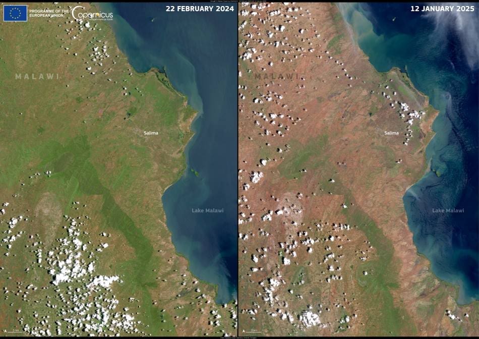
The stark reality of this environmental stress is captured in a comparison of Copernicus Sentinel-2 satellite images, taken on 22 February 2024 and 12 January 2025. The two images reveal a dramatic shift in vegetation cover across central and southern Malawi. In the earlier image, patches of green indicate healthier vegetation, while the more recent photograph shows widespread browning and drying, especially around Lake Malawi and the central plateau near the capital, Lilongwe. These areas, once verdant, now appear parched and vulnerable.

The Copernicus Sentinel-2 image vividly illustrates the scale of environmental change within less than a year. The once-lush landscapes now show signs of distress, a pattern that has become all too familiar across the region. Such imagery not only provides a visual record of environmental degradation but also serves a critical function in global drought monitoring and response.
The ongoing drought has far-reaching consequences for Malawi, where the majority of the population relies on rain-fed agriculture for food and income. Reduced crop yields, dwindling water supplies, and heightened food insecurity are immediate risks that threaten livelihoods. The Global Drought Observatory report warns that conditions are expected to worsen through 2025, urging governments and humanitarian organizations to prepare for an escalating crisis.
Satellite data like that from Copernicus plays an essential role in tracking vegetation health and soil moisture levels. These insights are vital for early warning systems that help authorities manage drought risks, allocate resources, and mitigate the most devastating impacts on affected communities. In regions like Malawi, where ground-based monitoring infrastructure is limited, the information provided by Earth observation satellites is indispensable.
As climate variability intensifies, southern Africa’s vulnerability to extreme drought events continues to grow. Tools like the Copernicus Emergency Management Service offer critical support to researchers, policymakers, and relief organizations, providing the data necessary to anticipate challenges and build resilience. The situation in Malawi is a sobering reminder of the urgent need for robust, coordinated responses to the escalating impacts of climate change.
Featured image credit: European Union, Copernicus Sentinel-2 imagery


