Summary:
Floodplains are often seen as passive zones during floods, but their diverse topographic features can play an active role in controlling flood behavior. A new study by researchers at the University of Vermont (UVM) reveals that the shape and structure of floodplains significantly influence how floodwaters travel and dissipate across a landscape.
Published in the Journal of Geophysical Research: Earth Surface, the study introduces a Hydraulic Floodplain Classification that categorizes floodplains based on their capacity to reduce flood momentum.
Using high-resolution LiDAR data from the Lake Champlain Basin of Vermont, the team developed an automated method to detect topographic features linked to flood attenuation. These features form what the researchers call an ‘Energy Dissipation Zone’ — areas within the floodplain that slow and store water more effectively than surrounding regions. By clustering these zones into six distinct types based on their geometry, the study offers a scalable framework to predict how different river reaches manage floodwaters.
This new classification system can enhance flood modeling, improve hazard forecasting, and support smarter watershed management. It also provides a valuable tool for identifying which areas are most effective for flood mitigation and should be prioritized for conservation or restoration — especially critical as climate change intensifies extreme weather.

Classifying floodplains: an innovative approach to flood mitigation
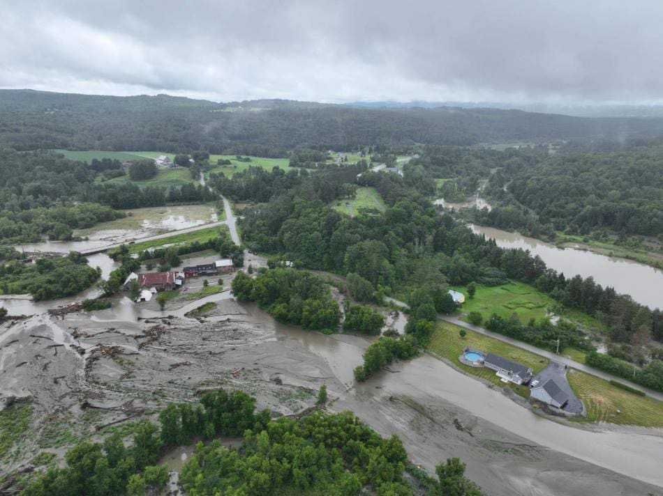
As extreme weather and flooding events become more intense and frequent due to climate change, improving flood mitigation strategies has never been more critical. The livelihood of downstream communities relies heavily on effective flood resilience measures to reduce flood levels and decrease the power of flood waters.
Floodplains — low-lying areas adjacent to rivers and streams — can play a crucial role in reducing flood impacts, helping to protect lives, agriculture, and infrastructure by influencing how water moves across the landscape. Acting as a natural buffer, floodplains temporarily store floodwater, reducing flood peaks and minimizing the erosional power, in a phenomenon called attenuation.
However, new research by the University of Vermont (UVM) shows that not all floodplains function in the same way. The study reveals that varying topographic features affect a floodplain’s ability to ease flood water’s momentum and impact.
The team introduces an innovative method to detect floodplains and classify them based on their ability to attenuate floods. “This approach enables the assessment of floodplains and their processes across broad scales to better account for their functions and potential to contribute to flood resilience,” said Dr. Rebecca Diehl, the study’s lead researcher. “Floodplains typically aren’t included in large-scale water resource assessments, such as flood prediction models, yet, they can play a significant role in routing floods across the landscape and determining the impacts of floods.”
The study leverages widely available topographic datasets to identify features along the edge of the river channel that are hypothesized to slow floodwaters to a greater degree than the surrounding area. Floodplain settings were then grouped based on the presence, size, and shape of these features. When the research team evaluated the ability of each type of setting to store and slow floodwaters, they found distinct differences among them, demonstrating a clear relationship between flood routing and topography.
This process was demonstrated in the Lake Champlain Basin in Vermont, spanning elevations from 1,339 m to 29 m, through the steep gradients of the Green and Taconic Mountains to the lowlands of the Champlain and Hudson Valleys. The study revealed six distinct floodplain types present in the region, each playing a unique role in attenuating flooding.
The resulting concept, the Hydraulic Floodplain Classification, emphasizes the landscape’s variable capacity to influence flood routing. While the initial study was conducted in the northeastern United States, the workflow and concepts proposed are transferrable, allowing it to be applied to other regions and watersheds across the country, offering a versatile tool for water resource assessments and floodplain management applications.
Implications for watershed management and restoration
By pinpointing floodplains that are most effective at slowing floodwaters, the study provides valuable insights for restoration and conservation projects. Understanding which attributes have the greatest potential for attenuation can help guide watershed management by prioritizing sites for floodplain reconnection, infrastructure removal, or riparian revegetation, and guiding restoration design.
Notably, classification systems such as the one proposed by the researchers can be effective communication tools, enabling policymakers and planners to make data-driven decisions about restoration and land use. By easing identification of naturally attenuating features, the approach can support flood resilience plans that rely on natural landscapes.
“By classifying rivers based on the presence of floodplains and their attenuation potential, we are building a broad-scale understanding of how the landscape can influence flood routing, and which parts may best contribute to flood resilience projects,” says Diehl, a Research Associate Professor in the University of Vermont’s Department of Geography and Geosciences. “Communities will be able to determine whether a focus on upstream watershed management to slow the flow will be an effective part of their flood resilience plan.”
Additionally, this work highlights the importance of preserving natural floodplains, particularly as climate change continues to increase the frequency and intensity of storms. Floodplains not only slow the force of water, but they also support the deposition and storage of sediment, nutrients, and pollutants, ultimately improving water quality.
Enhancing flood forecasting and community preparedness
Proper representation of flood routing across the landscape is critical for accurate flood forecasting. Often, models developed to make predictions over large areas have limited information on the characteristics of rivers, floodplains, and the interaction of water with the landscape, resulting in errors in flood warnings, putting lives and property in danger.
Understanding the unique hydraulic characteristics of floodplains is key to better managing flood risks and protecting communities. The Hydraulic Floodplain Classification provides a pathway towards improved representation of natural features and processes in large-scale models improving streamflow predictions and flood inundation mapping. Such an outcome can enhance operational flood warnings, helping downstream communities better prepare for flood events.
Journal Reference:
Diehl, R. M., Lawson, K. S., Underwood, K. L., Scamardo, J. E., Clemins, P. J., & Wemple, B. C., ‘Identifying hydraulically distinct floodplain types from high resolution topography with implications for broad-scale flood routing’, Journal of Geophysical Research: Earth Surface 130, e2024JF007984 (2025). DOI: 10.1029/2024JF007984
Article Source:
Press Release/Material by Hannah Fischer | University of Vermont
Featured image: East Montpelier in July of 2024. Credit: Photo by Vermont Agency of Transportation