A powerful 7.7 magnitude earthquake struck Myanmar on 28 March 2025, causing widespread destruction across the country. The earthquake’s epicenter was near Mandalay, Myanmar’s second-largest city, where the tremors led to the collapse of buildings, bridges, and key infrastructure. More than 1,700 people lost their lives, while at least 3,400 were injured in the disaster.
The historic Ava Bridge, which spans the Irrawaddy River and has connected communities for over a century, was among the structures that collapsed. Across affected areas, homes, roads, and public buildings were reduced to rubble, displacing thousands and severely impacting access to critical resources.

To assess the extent of the damage, the Copernicus Emergency Management Service (CEMS) activated its Rapid Mapping module (EMSR798), focusing on 11 key areas of interest. This satellite-based monitoring system provides rapid damage assessments to support emergency responders and humanitarian aid efforts.
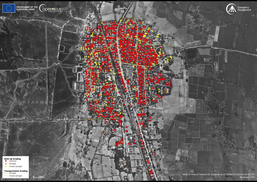
The image shown here is a data visualization based on CEMS data, highlighting the devastation in the village of Pha Duu (Pa Du). According to the analysis, more than 1,200 buildings and 8 kilometers of roads in the village were either damaged or destroyed. This information helps authorities prioritize relief efforts and allocate resources to the worst-affected areas.
As rescue operations continue, international organizations and local responders are working to provide aid to survivors. A detailed report on the emergency response has been published, along with all maps and related data, on the Copernicus EMS website.
Featured image credit: European Union, Copernicus Emergency Management Service Data


