Summary
A devastating flood disaster in the Himalayas in October 2023 has highlighted the increasing risk of successive natural hazards in high mountain regions due to climate change.
An international research team, including scientists from the University of Zurich, investigated the causes of the flood cascade along the Teesta River in Sikkim, India, which resulted in massive destruction, at least 55 deaths, and 70 people missing.
The study, published in Science, found that the disaster began when 14.7 million cubic meters of moraine material collapsed into South Lhonak Lake, triggering a glacial lake outburst flood that released 50 million cubic meters of water. The event generated a powerful flood wave, destroying infrastructure, hydroelectric power plants, and farmland.
Researchers used high-resolution satellite data, seismic analysis, and numerical simulations to reconstruct the disaster in detail, revealing that warning signs had been present years before. The study stresses the need for early warning systems, stronger hydropower regulations, and improved risk assessment strategies to reduce future disasters in the Himalayas and other mountain regions.

An international study has investigated the causes and impacts of the devastating flood disaster in the Himalayas in October 2023, which destroyed large areas along and surrounding the Teesta River in Sikkim, India. A research team from nine countries, including researchers from the University of Zurich (UZH), analyzed the complex drivers, causes and consequences of this flood cascade and reconstructed the exact time of its onset.
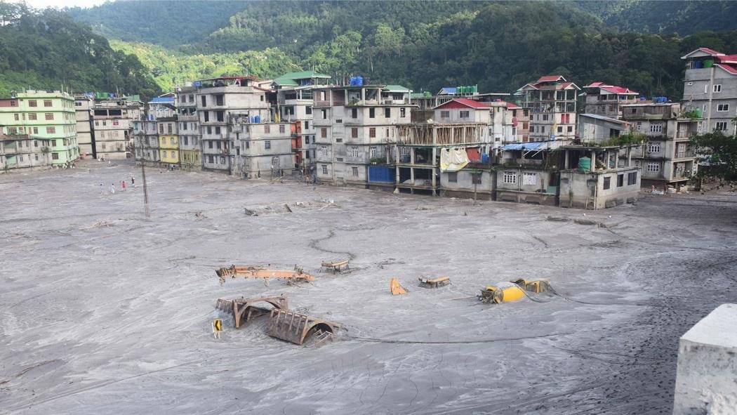
Massive damage caused by tsunami wave
On 3 October 2023, approximately 14.7 million cubic meters of frozen moraine material collapsed into South Lhonak Lake, triggering a tsunami-like impact wave up to 20 meters high. The subsequent glacial lake outburst flood breached the moraine and released approximately 50 million cubic meters of water – enough to fill 20,000 Olympic-sized swimming pools.
The flood caused massive damage along the 385-kilometer-long valley, washing away some 270 million cubic meters of sediment and inundating infrastructure such as hydroelectric power plants on the Teesta River. At least 55 people were killed, and 70 others were reported missing.
“This event is a stark reminder of the vulnerability of high mountain regions to the effects of climate change,” says Christian Huggel, co-author of the study and head of the Environment and Climate research group at UZH. “The thawing of permafrost and the instability of rock, ice and moraine structures pose major risks.”
High-resolution remote sensing data crucial
Using state-of-the-art scientific methods, the researchers analyzed the dynamics and effects of the flood disaster in detail. High-resolution satellite images, digital elevation models and numerical simulations provided a detailed reconstruction of the event.

Seismic data helped the researchers to determine the exact time of the moraine collapse, while geomorphological analyses quantified the volume of water and sediment released. The combination of satellite technology and physical models provided a comprehensive picture of the disaster and its far-reaching consequences.
“The use of high-resolution remote sensing data was crucial to understanding the complex processes and cascading effects of the flood in detail,” explains first author Ashim Sattar, a former postdoctoral researcher at UZH and now an assistant professor at the Indian Institute of Technology in Bhubaneswar. “Collaboration among researchers from different disciplines was key in gaging the full extent of this event.”
Urgent need for early warning systems
The flood not only destroyed infrastructure, including five hydroelectric power plants, but also caused massive erosion and sedimentation, with serious consequences for farmers and local businesses.
“Our findings highlight the urgent need for early warning systems and international cooperation to address such challenges,” emphasizes Sattar. The study also shows that the instability of the moraines had been evident years before the event, with shifts of up to 15 meters per year. This underlines the need for coordinated monitoring of critical high mountain areas and further preventive measures that could have mitigated the damage.
Better risk assessment
The researchers emphasize that similar disasters are likely to become more common in the future as rising temperatures increase the risk of glacial lake outbursts. “The case of South Lhonak Lake is a reminder to take climate risks in mountain regions worldwide more seriously,” says Huggel.
Ashim Sattar adds: “We need better risk modeling and assessment, as well as robust adaptation strategies, to minimize future disasters.”
The team also calls for stronger regulation of hydropower development in high-risk areas, better monitoring of glacial lakes, and the integration of early warning systems. The study provides important insights that can help to better prepare local communities for the growing challenges of climate change.
Journal Reference:
Ashim Sattar et al., ‘The Sikkim flood of October 2023: Drivers, causes and impacts of a multihazard cascade’, Science eads2659 (2025). DOI: 10.1126/science.ads2659
Article Source:
Press Release/Material by University of Zurich
Featured image: Flooding and destruction of Rangpo, over 130 km downstream of South Lhonak Lake. Credit: Praful Rao