Changes in store for atmospheric rivers
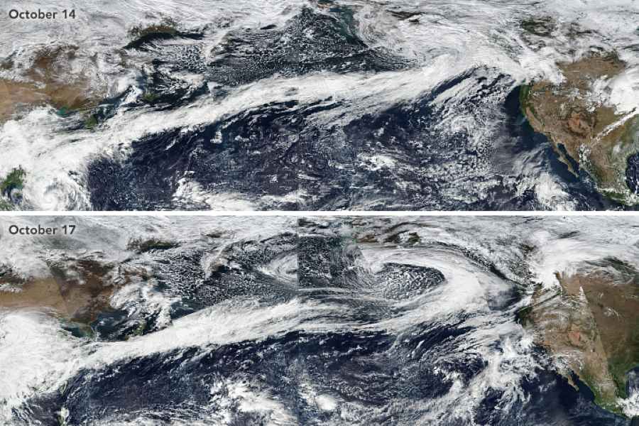
David Hosansky | UCAR – Communities up and down the West Coast of the United States can expect the potent storms known as atmospheric rivers to evolve as the climate warms. But residents in Southern California will see much different changes than residents in more northerly locations like Seattle.
New research, led by scientists at the U.S. National Science Foundation National Center for Atmospheric Research (NSF NCAR), found that warming conditions will increase evaporation of ocean waters and significantly alter atmospheric rivers to the south. Farther north, however, atmospheric rivers will be most influenced by rising temperatures in the ocean and atmosphere.
While such differing processes may seem arcane, they will have real-world consequences for millions of people. By 2100, for example, atmospheric rivers that strike the Pacific Northwest could increase flooding risks by temporarily raising the heights of ocean waters as much as three times more than current storms if society continues to emit greenhouse gases at a high rate. Residents of Southern California will also experience higher storm-driven waters, but not to the extent of those living farther north.

“On the ground, people will see a different response between the Southern California coast and the Pacific Northwest,” said NSF NCAR scientist Christine Shields, a co-lead author of the new study. “It’s not a one-size-fits-all situation. You have these regional responses that can be quite different.”
The study, published in Communications Earth & Environment, was conducted by a research team that included co-lead author NSF NCAR scientist Hui Li and additional co-authors from NSF NCAR, Texas A&M University, and Pennsylvania State University. The work was funded by the U.S. Department of Energy and NSF.
Rivers in the sky
Atmospheric rivers are long and narrow “rivers in the sky” that meander from lower to higher latitudes, transporting enormous amounts of water. The most powerful atmospheric rivers can unleash torrential rains and cause widespread flooding, especially when they stall over vulnerable watersheds. But they’re also a vital feature of Earth’s hydrological cycle, often delivering needed moisture and replenishing snowpacks.
Past research has shown that climate change is likely to make atmospheric rivers larger and stronger, potentially wreaking more havoc on vulnerable communities. As is the case with other types of storms, a warmer climate means the atmosphere can hold more moisture, thereby increasing the amount of precipitation that a storm can release.
In the new study, Shields, Li, and their co-authors focused on the impacts of Pacific atmospheric rivers on the upper region of the ocean. They wanted to gain insights into how future storms are likely to affect oceanic variables such as the surface temperature and height and the mixing of waters at different depths. Such variables have implications for fisheries and coastal communities.
To simulate future atmospheric rivers, the research team used a high-resolution version of the NSF NCAR–based Community Climate System Model. This enabled them to get an unusually detailed view of atmospheric processes every 25 kilometers (about 16 miles) and an even more detailed view of ocean processes every 10 kilometers (6 miles) – a simulation so fine that they could recreate individual ocean eddies. The simulations required large amounts of computing, and the scientists ran some of them on the Derecho supercomputer at the NSF NCAR-Wyoming Supercomputing Center.
To the surprise of the scientists, the simulations revealed that a warming climate will have greatly varying impacts on atmospheric rivers in different locations along the West Coast – and, potentially, other regions around the globe.
Atmospheric rivers currently are driven in part by the evaporation of ocean waters, which temporarily cools the atmosphere and propels the storms forward. In a warmer world, that process will be amplified for a type of atmospheric river, known as a “Pineapple Express,” that plows into Southern California.
But atmospheric rivers that crash into Northern California and the Pacific Northwest will begin to be affected instead by warmer temperatures in both the atmosphere and ocean. These temperatures will fuel more powerful storms and lead to a dramatic increase in sea level height for several days as the atmospheric river approaches the coast and makes landfall.
Although more research is needed to tease out the reason for these differing effects, Shields noted that atmospheric rivers are affected by varying processes even in the current climate. The Pineapple Express, for example, moves along a subtropical jet of very moist air from Hawaii to Southern California. In contrast, atmospheric rivers to the north are often connected with a less moist polar jet of air. They tend to be windier and more meandering than the Pineapple Express.
Regardless of the processes, vulnerable communities on the West Coast can expect the storms to change and become more powerful.
“Atmospheric rivers are like tropical cyclones in that they pack powerful winds and carry enormous amounts of water that can devastate local infrastructure,” Shields said. “Communities need to understand how they will change in the future so they can adapt and plan.”
The modeling also showed that the complex downstream and upstream effects of atmospheric rivers on the upper region of the ocean will evolve as the climate warms.
“The strong winds and precipitation linked to atmospheric rivers can significantly impact the upper ocean, potentially impacting ocean dynamics and ecosystems over larger spatial scales and longer timescales than the present,” Li said. “It is important to understand the influence of atmospheric rivers under the current climate and how they may change in the future.”
Journal Reference:
Shields, C.A., Li, H., Castruccio, F.S. et al. ‘Response of the upper ocean to northeast Pacific atmospheric rivers under climate change’, Communications Earth & Environment 5, 603 (2024). DOI: 10.1038/s43247-024-01774-0
Article Source:
Press Release/Material by National Center for Atmospheric Research | University Corporation for Atmospheric Research
Geothermal aquifers offer green potential but quality checks required
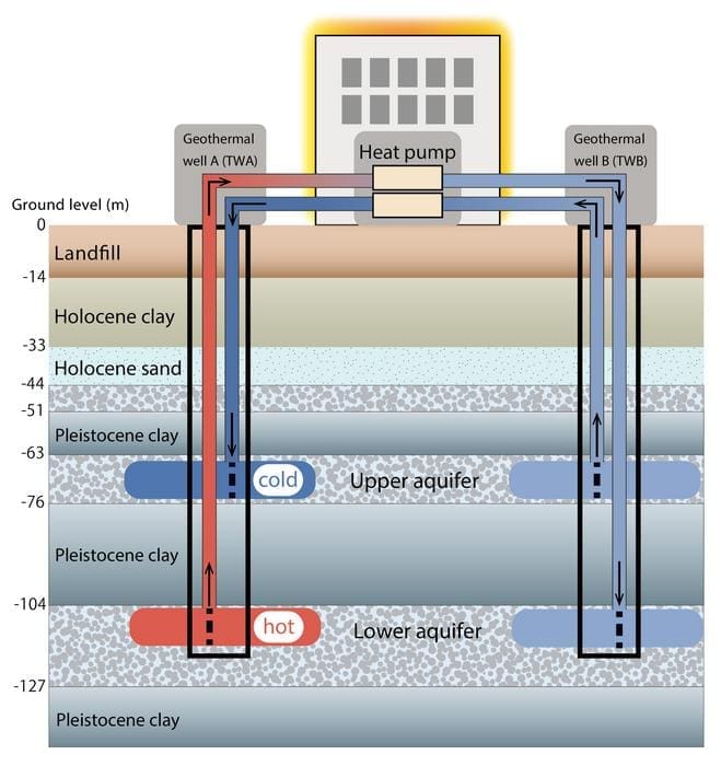
Osaka Metropolitan University – The aquifer thermal energy storage (ATES) system, which uses geothermal heat as a renewable energy source, is one of the solutions to reducing fuel consumption and carbon dioxide emission. This system stores heat underground in aquifers, using groundwater as a heat medium. The heat is then extracted as needed according to the season to efficiently heat and cool buildings.

Its use is mainly expanding in Europe, and its widespread introduction is expected in Japan. However, regular inspection is required to utilize these systems without faults.
This fact became evident when a research group led by Specially Appointed Professor Harue Masuda at the Osaka Metropolitan University Urban Resilience Research Center identified clogging that occurred in the plumbing pipe of an ATES well at a facility in Osaka.
The findings are published in Geothermics.
In their study, iron oxyhydroxide precipitation occurred after a vent was accidentally left open, allowing for air to enter the geothermal wells through plumbing pipes. In turn, an oxygen-rich environment formed and iron oxyhydroxide spread through the piping, causing a clog, leak, and subsequent mixing of groundwater between two aquifers at different depths of each well. Fortunately, natural microbial activity resolved the clog and restored the groundwater.
Observation of this chain of events revealed that it is crucial to evaluate the water quality before the well is put into operation, and to continuously monitor for long-term use of the ATES system.
“The results of this research show that geochemical analysis of groundwater, which has not been emphasized in the engineering field until now, is effective and essential for the stable, widespread use of the ATES system,” stated Professor Masuda. “We believe that by proposing a method for monitoring water quality as a guideline, we can establish the ATES system as a technology that can be used for the long term.”
Journal Reference:
Harue Masuda, Yasuhisa Nakaso, Masaki Nakao, Linri Cui, ‘Natural recovery from Fe-oxyhydroxide clogging of a geothermal well in Osaka, Japan’, Geothermics 125, 103187 (2024). DOI: 10.1016/j.geothermics.2024.103187
Article Source:
Press Release/Material by Osaka Metropolitan University
Early warning tool will help control huge locust swarms
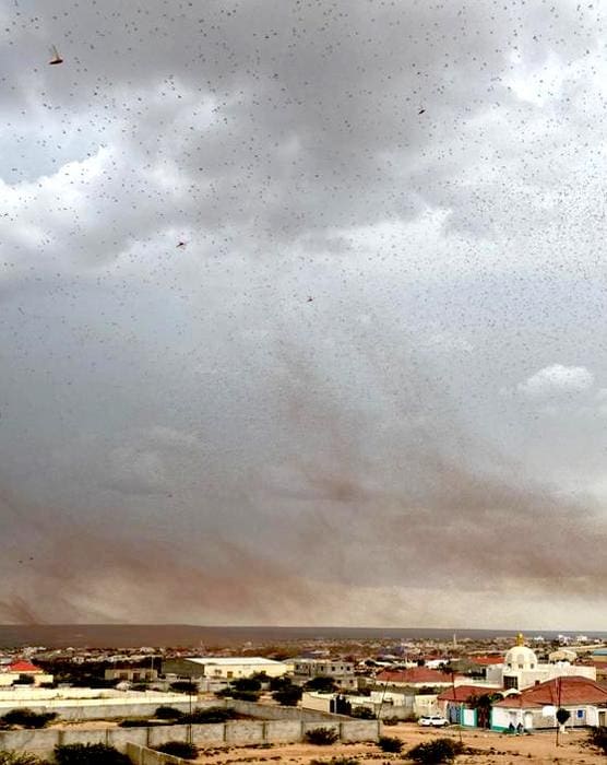
University of Cambridge – Desert locusts typically lead solitary lives until something – like intense rainfall – triggers them to swarm in vast numbers, often with devastating consequences.
This migratory pest can reach plague proportions, and a swarm covering one square kilometre can consume enough food in one day to feed 35,000 people. Such extensive crop destruction pushes up local food prices and can lead to riots and mass starvation.
Now a team led by the University of Cambridge has developed a way to predict when and where desert locusts will swarm, so they can be dealt with before the problem gets out of hand.
It uses weather forecast data from the UK Met Office, and state-of the-art computational models of the insects’ movements in the air, to predict where swarms will go as they search for new feeding and breeding grounds. The areas likely to be affected can then be sprayed with pesticides.

Until now, predicting and controlling locust swarms has been ‘hit and miss’, according to the researchers. Their new model, published in the journal PLOS Computational Biology, will enable national agencies to respond quickly to a developing locust threat.
Desert locust control is a top priority for food security: it is the biggest migratory pest for smallholder farmers in many regions of Africa and Asia, and capable of long-distance travel across national boundaries.
Climate change is expected to drive more frequent desert locust swarms, by causing trigger events like cyclones and intense rainfall. These bring moisture to desert regions that allows plants to thrive, providing food for locusts that triggers their breeding.
“During a desert locust outbreak we can now predict where swarms will go several days in advance, so we can control them at particular sites. And if they’re not controlled at those sites, we can predict where they’ll go next so preparations can be made there,” said Dr Renata Retkute, a researcher in the University of Cambridge’s Department of Plant Sciences and first author of the paper.
“The important thing is to respond quickly if there’s likely to be a big locust upsurge, before it causes a major crop loss. Huge swarms can lead to really desperate situations where people could starve,” said Professor Chris Gilligan in the University of Cambridge’s Department of Plant Sciences, senior author of the paper.
He added: “Our model will allow us to hit the ground running in future, rather than starting from scratch as has historically been the case.”
The team noticed the need for a comprehensive model of desert locust behaviour during the response to a massive upsurge over 2019-2021, which extended from Kenya to India and put huge strain on wheat production in these regions. The infestations destroyed sugarcane, sorghum, maize and root crops. The researchers say the scientific response was hampered by the need to gather and integrate information from a range of disparate sources.
“The response to the last locust upsurge was very ad-hoc, and less efficient than it could have been. We’ve created a comprehensive model that can be used next time to control this devastating pest,” said Retkute.
Although models like this have been attempted before, this is the first that can rapidly and reliably predict swarm behaviour. It takes into account the insects’ lifecycle and their selection of breeding sites, and can forecast locust swarm movements both short and long-term.
The new model has been rigorously tested using real surveillance and weather data from the last major locust upsurge. It will inform surveillance, early warning, and management of desert locust swarms by national governments, and international organisations like the Food and Agriculture Organisation of the United Nations (FAO).
The researchers say countries that haven’t experienced a locust upsurge in many years are often ill-prepared to respond, lacking the necessary surveillance teams, aircraft and pesticides. As climate change alters the movement and spread of major swarms, better planning is needed – making the new model a timely development.
Journal Reference:
Retkute R, Thurston W, Cressman K, Gilligan CA, ‘A framework for modelling desert locust population dynamics and large-scale dispersal’, PLoS Computational Biology 20 (12): e1012562 (2024). DOI: 10.1371/journal.pcbi.1012562
Article Source:
Press Release/Material by University of Cambridge
Dripstones offer insights into climate dynamics in Europe
Heidelberg University – Investigations into precipitation patterns in eastern Central Europe since the end of the last ice age, conducted by an international research team led by Dr Sophie Warken of Heidelberg University, have shown that dynamic processes in atmospheric circulation, such as the North Atlantic jet stream, influence regional changes in precipitation.
The researchers analyzed dripstones from the Cloşani Cave in Romania, which act as a natural climate archive that allows conclusions to be drawn about precipitation variability over a period of approximately 20,000 years. According to Dr Warken, the new findings on the dynamics of the climate in Europe could contribute to improving current climate models and the ability to more accurately predict the likelihood of extreme weather events.
Of particular importance for the regional weather and precipitation patterns in Europe’s mid-latitudes is the North Atlantic jet stream, an atmospheric air flow that crosses the North Atlantic in a southwest-to-northeast direction carrying precipitation to Europe. In the past, climatic changes did affect the strength and trajectory of the jet stream – that much is known. But as Dr Warken explains, our understanding of how climate-induced fluctuations in the jet stream influenced local and regional precipitation patterns in Europe is limited.
The results were published in the journal Communications Earth & Environment.

Natural climate archives, like the dripstones in the Cloşani Cave in Romania, can provide information on the climate dynamics of bygone ages. The lime deposits, also known as speleothems, form from precipitation that seeps into the cave’s interior over several thousands of years.
Geochemical investigations allow conclusions to be drawn about the chronology of the deposits and thus past environmental conditions and precipitation amounts. The current study focused on three stalagmites that contain information on the hydroclimatic conditions in eastern Central Europe over the past 20,000 years.
The results show how the trajectory of the North Atlantic jet stream changed due to the warming and melting of the ice sheets of the Northern hemisphere – a process that lasted until about 5,000 years ago. As a result, precipitation in the late last Ice Age about 20,000 years ago and the early to mid-Holocene – the current interglacial epoch that followed the last Ice Age about 7,000 years ago – was 20 to 30 percent higher than it is today. It turns out that precipitation variability in the region over comparatively short time periods of centuries or even just decades fluctuated irrespective of long-term temperature developments in the North Atlantic region.
“Our research shows that dynamic processes in particular, such as changes in wind patterns and atmospheric currents like the jet stream, influence the precipitation and weather patterns in Central Europe,” stresses Dr Warken.
This helps fill in a research gap, she explains, because former reconstructions mainly refer to thermodynamic processes, i.e., the warming of the atmosphere, and thereby directly connect a rise in temperature to an increase in precipitation. These reconstructions are often based on climate models still fraught with uncertainties in simulating local and regional precipitation patterns.
“Climate change is already leading to more frequent and intense precipitation events; based on current prognoses, the number of extreme weather events and heavy rainfall in several regions in Europe will continue to rise,” states Dr Warken. A better understanding of the underlying dynamic processes is key to more accurately predict future precipitation patterns and the likelihood of extreme weather events.
Against this backdrop, the current results from the Cloşani Cave can help improve the accuracy of climate models and prognoses, adds the geoscientist, who together with her research group at the Institutes of Earth Sciences and Environmental Physics of Heidelberg University is reconstructing the climate of past millennia.
***
The research was carried out in collaboration with scientists from the Universities of Mainz and Innsbruck (Austria). Also, involved were other institutions in Germany and Romania.
Journal Reference:
Warken, S.F., Riechelmann, D.F.C., Fohlmeister, J. et al. ‘Dynamic processes determine precipitation variability in Eastern Central Europe since the Last Glacial Maximum’, Communications Earth & Environment 5, 694 (2024). DOI: 10.1038/s43247-024-01876-9
Article Source:
Press Release/Material by Heidelberg University
Featured image credit: Gerd Altmann | Pixabay


