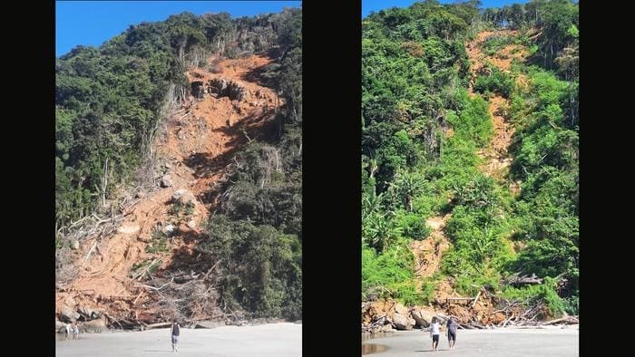
Researchers at the University of São Paulo (USP) are pioneering a high-resolution model to assess landslide risks in São Sebastião, a coastal municipality in São Paulo state, Brazil, where severe landslides in early 2023 led to extensive damage.
A team of researchers has created a detailed inventory of more than 1,000 landslide points across the area, using aerial images collected shortly after the disaster. By leveraging advanced LIDAR (Light Detection and Ranging) technology, the scientists try to find out how the inventory correlates with other variables and to develop a method for mapping the risk of landslides more precisely.

This project, spearheaded by the University of São Paulo’s Institute of Astronomy, Geophysics and Atmospheric Sciences (IAG-USP) in collaboration with the São Paulo State Institute of Geography and Cartography, involves generating precise 3D images of São Sebastião’s topography.
In the wake of the 2023 disaster, these images are being analyzed to map landslide susceptibility with unprecedented accuracy. According to Carlos Henrique Grohmann, a full professor at IAG-USP and leader of the project, , which is supported by FAPESP,: “In this type of analysis, known as a landslide susceptibility assessment, knowledge of the areas in which landslides occurred, including topographical, geological and other data, is extrapolated for other areas.”
Traditionally, models of this nature have used data with a spatial resolution (pixel size) of 30 meters, a measure that Grohmann and his team believe lacks sufficient detail for highly localized predictions.
“The LIDAR data lets us go a step farther and apply elevation models with higher resolution [as high as 1 m] and more precision,” Grohmann told Agência FAPESP. This higher level of resolution, made possible through LIDAR, provides an intricate understanding of terrain changes without interference from vegetation or built structures.
The technology, which measures distances using pulsed lasers, is proving invaluable in mountainous regions like São Sebastião’s Serra do Mar, where landslides are frequent and destructive, particularly during intense summer rainfall.
In February 2023, São Sebastião was hit by a record-breaking 683 millimeters of rain within a 15-hour period, prompting a state of emergency. The rainfall, more than double the monthly average, triggered deadly landslides that claimed 60 lives, left hundreds homeless, and severely impacted infrastructure.
Roads were buried or blocked, leaving entire sections of the municipality inaccessible. This extreme weather underscores a broader trend of increasingly severe climate events – a concern echoed by global scientific assessments. As noted in the IPCC’s 2023 Climate Change Synthesis Report, the global surface temperature has risen by 1.1 °C since the preindustrial period and is on track to reach 1.5 °C above that baseline by 2035.
As São Sebastião continues to recover, the local government has renewed its focus on hazard management. An agreement between the municipality and the Technological Research Institute (IPT) aims to update high-risk maps, particularly in hard-hit neighborhoods like Barra do Sahy, Boiçucanga, and Juquehy. These areas remain under threat as loss of vegetation has left slopes more vulnerable.
Grohmann emphasizes the importance of this data-driven approach to prevention: “What happened in São Sebastião last year was an anomaly, but heavy rainfall is usual in summer, and landslides are frequent. The point is that areas once covered with vegetation have lost this protection and are now highly vulnerable.”
Looking ahead, the team expects to complete its new landslide susceptibility model by the end of 2025. This timeline will allow researchers and policymakers to develop more proactive mitigation strategies, helping to safeguard São Sebastião’s population and infrastructure.
The researchers’ approach combines high-definition aerial surveys and digital elevation models, providing insights into the region’s shifting landscape. Alongside these innovations, the project also enables a morphometric characterization of critical areas, tracking changes in topography and vegetation in landslide-prone zones such as Toque-Toque Grande and Morro da Baleia.
This inventory of landslide points, published in the Brazilian Journal of Geology, marks the first time such comprehensive LIDAR data is available for the Serra do Mar region. With open access to this data via the Zenodo repository, USP researchers hope to extend their findings’ impact, providing tools that can be adapted by other high-risk regions as the frequency of extreme weather events continues to rise.
Journal Reference:
Rebeca Durço Coelho, Camila Duelis Viana, Vivian Cristina Dias, Carlos Henrique Grohmann, ‘Landslides of the 2023 summer event of São Sebastião, southeastern Brazil: spatial dataset’, Brazilian Journal of Geology 54 (2), (2024). DOI: 10.1590/2317-4889202420240006
Article Source:
Press Release/Material by Fundação de Amparo à Pesquisa do Estado de São Paulo (FAPESP)
Featured image credit: Roosewelt Pinheiro/ABr | CC BY 3.0 BR, via Wikimedia Commons


