Scientists at the Alfred Wegener Institute (AWI) have introduced a new tool that sheds light on the direct influence of climate change on specific weather events.
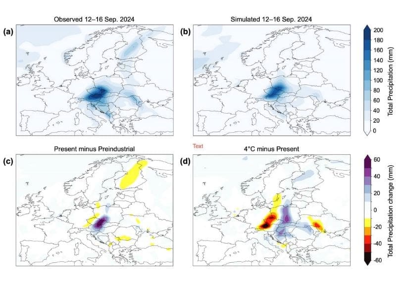
Using a method called “storylines,” the AWI team analyzed the intense rainfall from storm Boris, which recently caused severe flooding across Central and Eastern Europe. Their findings suggest that without the warming effects of climate change, Boris would have produced around nine percent less rainfall.
Published in Communications Earth & Environment, this method offers a new way to explore how climate change amplifies extreme weather in real-time, allowing the public to see climate fingerprints in both daily and extreme weather events through an interactive online tool.

How much climate change is in the weather?
Alfred Wegener Institute, Helmholtz Centre for Polar and Marine Research – New AWI simulations make it possible to compare actual extreme weather events in various climate scenarios, and to gauge the role of global warming in connection with these extremes in the process
Only a few weeks ago, massive precipitation produced by the storm Boris led to chaos and flooding in Central and Eastern Europe. An analysis conducted by the Alfred Wegener Institute shows that in a world without the current level of global warming Boris would have deposited roughly nine percent less rain. Such conclusions can be drawn thanks to a new modelling approach called ‘storylines’.
How it can be used in near-real-time was just presented in the Nature journal Communications Earth & Environment. At the same time, the AWI team released a freely available online tool that allows users to identify the fingerprints of climate change in current extreme weather events and create their own comparison graphics.
In mid-September, the storm Boris produced torrential rains and extreme flooding in Poland, the Czech Republic, Austria and Romania. In many of the affected regions, it was one of the highest amounts of precipitation ever recorded in a five-day period. There were at least 27 fatalities, while countless families were forced to leave their homes. In the meantime, the situation has improved and cleanup efforts are running round the clock. But already the next weather extremes, this time in Spain, are cause for concern. Time and time again, a central question arises in public, political, and media forums: was the catastrophe caused by global climate change?
“For the past few years, science has been able to provide robust answers to this absolutely legitimate question,” says lead author Dr Marylou Athanase, a physicist in the Climate Dynamics Section of the Alfred Wegener Institute, Helmholtz Centre for Polar and Marine Research (AWI). “As early as one or two weeks after a given event, so-called probabilistic attribution studies can be used to draw initial conclusions on how much more probable the event was, due to climate change.”
The only problem: probabilities are often somewhat intangible, especially when they collide with concrete and exceptional, real-world events. When it comes to external communications – with the public and decision-makers – the scientific community has never had a tool that could show the influence of global climate change on the actual local weather in an impressive yet readily understandable way.
“That’s why we at the AWI have worked so hard to advance a totally new way – the ‘storyline’ approach,” explains Dr Antonio Sánchez-Benítez, a fellow physicist in the Climate Dynamics Section and co-lead author of the study. “Essentially, we apply the ‘what if?’ principle. What would a given catastrophe look like in a world without climate change? And what about in a climate that was even warmer? By comparing the hypothetical scenarios with the reality, we can then very clearly identify the fingerprints of climate change – and not just for extreme weather events, but also for day-to-day weather.”
Using storm Boris as an example, the AWI experts have now demonstrated what the new approach can do in the Nature journal Communications Earth & Environment. A comparison of the scenarios shows: without global warming, Boris would have deposited roughly nine percent less rain.
In reality, however, on its way from the eastern Mediterannean and the Black Sea toward Central Europe, the storm was able to gather in intensity because the water was roughly two degrees Celsius warmer than preindustrial levels – which meant a correspondingly higher percentage of water vapour in the air above the region.
Nine percent might not sound like much, but when it comes to the consequences of heavy rains, it always comes down to how much water gathers on the surface and where it all goes – can a river, a dam, or a sewage system hold it, or does it spill over, doing tremendous damage in the process?
But how did the experts manage to connect climate model-based simulations, which are mainly designed for long-term trends, with the actual local weather?
“One important aspect is what is known as ‘nudging’”, explains Dr Helge Gößling, a climate physicist and team lead of the storyline research at the AWI. “Climate models normally simulate a specific, quasi-random sequence of weather conditions, which is consistent with the laws of physics that their programming is based on. In order to identify differences in the climate, you need to see whether the mean values and distributions change, over a long period of time with a correspondingly large number of weather conditions.”
“Likewise, in weather models the simulated conditions have very little to do with the reality after a few weeks; the actual weather can only be predicted to a limited extent. With the ‘nudging’, we provide the model with actually observed wind data, including phenomena like the jet stream, and we nudge the model a bit in the direction of the actually observed wind. In this way, we can accurately reproduce real weather in the real climate. Then we change the background climate of the model, for instance to a world untouched by climate change by reducing the greenhouse-gas concentrations and adjusting other aspects, and repeat the experiment.”
The model used is the CMIP6 version of the AWI climate model, which was also part of the base data for the IPCC’s Sixth Assessment Report. The wind data fed into the model stems from the ERA5 reanalysis produced by the European Centre for Medium-Range Weather Forecasts (ECMWF).
“We have since automated the system to the point where daily analyses on the current weather are run on the supercomputer at the German Climate Computing Center (DKRZ),” says Marylou Athanase. “The data is then transferred to an online tool that runs on the AWI’s servers and is freely accessible to everyone at https://climate-storylines.awi.de. The analyses are conducted with a three-day delay on ‘real-time’, after which they’re available online.”
“As a result, interested users can log on anytime to see the ‘Climate Change Signal of the Day’ for extremes and everyday weather, around the globe and in near-real-time, in the form of interactive maps and timelines, though for the time being, only data on the temperature and precipitation from 1 January 2024 onwards is available. Our goal is to promote a better understanding of the connections between climate change and extreme weather events, and to supply concrete and timely answers that can also be used in media coverage of these events.”
Journal Reference:
Marylou Athanase, Antonio Sánchez-Benítez, Eva Monfort, Thomas Jung, Helge F. Goessling, ‘How climate change intensified storm Boris’ extreme rainfall, revealed by near-real-time storylines’, Nature Communications Earth & Environment (2024). DOI: 10.1038/s43247-024-01847-0
Article Source:
Press Release/Material by Alfred Wegener Institute, Helmholtz Centre for Polar and Marine Research
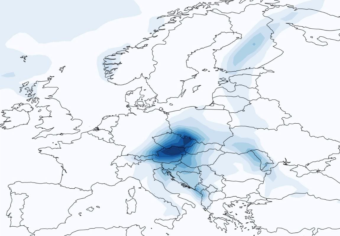
Featured image: Precipitation amounts September 2024. Credit: Marylou Athanase


