How a melting ice sheet reshaped North America’s coastline
Approximately 19,000 to 26,000 years ago, a vast ice sheet blanketed Canada and extended over parts of the northern United States, affecting regions as far south as present-day Pennsylvania, Ohio, Indiana, Michigan, and Wisconsin.

As this ancient ice sheet – known as the Laurentide ice sheet – retreated, it reshaped the Earth’s surface in ways that continue to influence land elevations and sea levels. This study by Karen Williams, a Ph.D. candidate at Virginia Tech, employs computational modeling to explore how these shifts in the Earth’s crust impact current land elevations and contribute to sea-level variations.
The research, recently published in the Journal of Geophysical Research: Solid Earth, reveals a nuanced understanding of glacial isostatic adjustment (GIA), the geological process by which the Earth’s crust responds to the melting of massive ice sheets.
Williams and her collaborators, including Associate Professor D. Sarah Stamps and colleagues from Italian institutions, ran 130,000 computational simulations to assess the vertical land motion caused by the melted Laurentide ice sheet. The results indicate a pattern of land sinking in the eastern United States, leading to relative sea-level rise, while in parts of eastern Canada, land is rebounding, causing local sea levels to drop.
Williams emphasizes that these model estimates provide insights into the drivers of land elevation changes, whether natural or anthropogenic, and underscore the importance of precision in predicting the impacts of coastal hazards. For example, the research team noted discrepancies between GIA effects and observed land sinking in areas like Houston, Texas, attributed to excessive groundwater extraction.
The study’s outcomes will support the development of predictive models and contribute to a U.S. Geological Survey report intended to aid coastal management in the Chesapeake Bay area.
Journal Reference:
Karen Williams, D. Sarah Stamps, Daniele Melini, Giorgio Spada, ‘Vertical Displacements and Sea-Level Changes in Eastern North America Driven by Glacial Isostatic Adjustment: An Ensemble Modeling Approach’, Journal of Geophysical Research: Solid Earth 129 (10): e2023JB028250 (2024). DOI: 10.1029/2023JB028250
Article Source:
Press Release/Material by Virginia Tech
Amazon rainforest faces threats as Atlantic currents shift
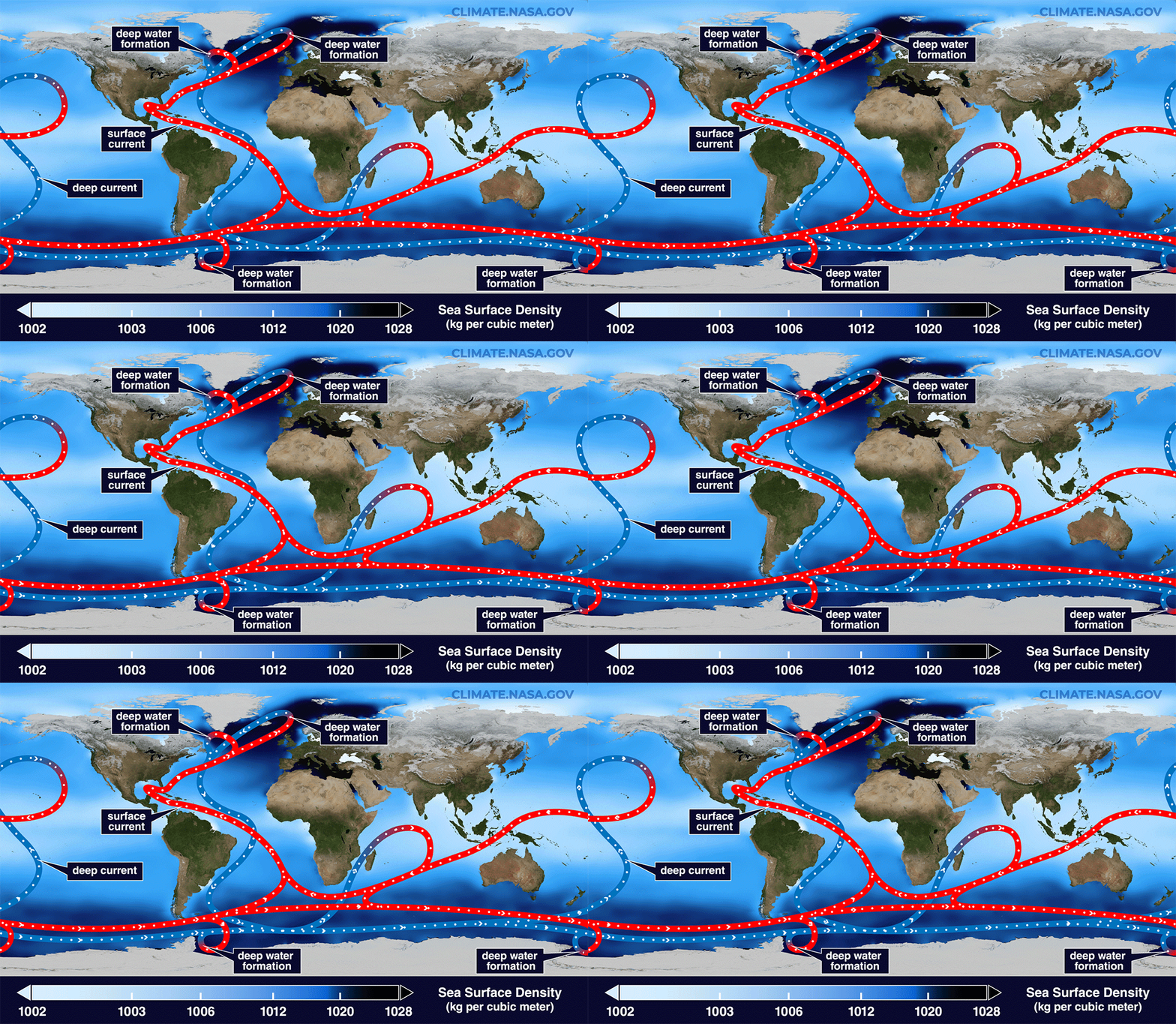
The Amazon rainforest, a vital ecosystem for global biodiversity and climate regulation, faces significant threats from both climate change and deforestation. Researchers have found that weakening in the Atlantic Meridional Overturning Circulation (AMOC), a critical component of global ocean circulation, could alter precipitation patterns and destabilize the Amazon region, creating a potential feedback loop.
An international research team, led by Dr. Thomas Akabane and Prof. Dr. Christiano Chiessi at the University of São Paulo, has published these findings in Nature Geoscience.

The team analyzed pollen and carbon residues from marine sediments spanning 25,000 years at the Amazon River’s mouth, allowing them to track how the AMOC’s historical weakening impacted rainforest vegetation.
Notably, the data highlighted a reduction in forest density in northern Amazon regions during past climate events known as Heinrich Events, when the AMOC drastically slowed. According to Dr. Stefan Mulitza of MARUM, while the Amazon adapted to previous changes in rainfall patterns linked to AMOC fluctuations, future weakening – combined with deforestation – could compromise its stability.
Climate modeling suggests even moderate AMOC changes could significantly affect the northern Amazon, highlighting a delicate balance in this interconnected system. Dr. Matthias Prange of MARUM cautions that impacts may extend globally, illustrating how distant climate events, like Greenland ice melt, influence ecosystems far from their origin. Prof. Dr. Gerrit Lohmann of AWI notes that such dynamics disproportionately affect populations with minimal contribution to climate change.
Journal Reference:
Thomas Akabane, Cristiano Chiessi, Marina Hirota, Ilham Bouimetarhan, Matthias Prange, Stefan Mulitza, Dailson Bertassoli Jr., Christoph Häggi, Arie Staal, Gerrit Lohmann, Niklas Boers, Anne-Laure Daniau, Rafael Oliveira, Marília Campos, Xiaoxu Shi, Paulo De Oliveira, ‘Weaker Atlantic overturning circulation increases the vulnerability of northern Amazon forests’, Nature Geoscience (2024). DOI: 10.1038/s41561-024-01578-z
Article Source:
Press Release/Material by MARUM – Center for Marine Environmental Sciences | University of Bremen
New model reveals underestimated carbon emissions from U.S. streams

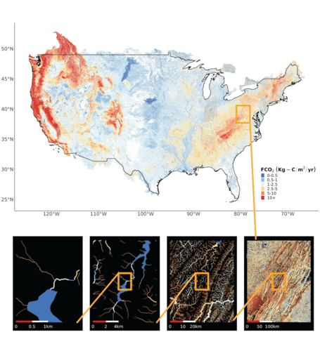
In a pioneering study, researchers at the University of Massachusetts Amherst used advanced modeling techniques to estimate carbon dioxide emissions from approximately 22 million lakes, rivers, and streams across the United States.
Published in AGU Advances, this study marks the first attempt to model inland water CO₂ emissions on such a large scale, revealing that prior estimates may have overestimated emissions by up to 25%.
Traditional methods averaged CO₂ levels across large regions, leading to potential inaccuracies. This new approach, led by Assistant Professor Matthew Winnick, modeled each water body individually, revealing considerable variation in emissions based on environmental factors such as water flow and source of CO₂.
The researchers discovered that turbulent mountain streams, which release CO₂ more quickly, and headwater streams, which absorb more CO₂ from groundwater, impact overall emissions differently than previously thought. Their simulations estimate 120 million metric tons of carbon emissions, compared to the 159 million metric tons estimated by prior methods.
These findings have implications for carbon sequestration initiatives aimed at offsetting emissions, as well as for understanding CO₂ dynamics under climate change.
Winnick points out that more accurate data on CO₂ sources, such as groundwater or near-stream sediment, will enable scientists to refine climate impact models. The study aims to encourage further investigation into how different environments contribute to carbon emissions, which could support future sequestration efforts and help in climate change mitigation.
Journal Reference:
Brian Saccardi, Craig B. Brinkerhoff, Colin J. Gleason, Matthew J. Winnick, ‘Toward Modeling Continental‐Scale Inland Water Carbon Dioxide Emissions’, AGU Advances 5 (6): e2024AV001294 (2024). DOI: 10.1029/2024AV001294
Article Source:
Press Release/Material by University of Massachusetts Amherst
Featured image credit: Gerd Altmann | Pixabay


